Length
8.17km

Elevation + / -
614m / 231m

Altitude Range
1905m / 2318m

When to go
Mid Jun - End Sep
Hike duration
2.0 - 4.0 Hours

Run duration
1.0 - 1.5 Hours

Technical level
Easy

Natural beauty
Incredible

Families
7+ Years old

Dogs
No Dogs

Provision Sources
2 Refuges, 2 Snack Bars

Trail type
With Lift
This route single handedly combines some of the major attractions of Chamonix in a single trail. It begins with the Montenvers mountain train which takes you from the center of Chamonix to the Montenvers mountain station. There you will be able to visit the Grotte de la Mer de Glace, a spectacular ice cave carved out in the Mer de Glace glacier. An unforgetable experience. Also at Montenvers you can visit the Galerie des Cristeaux which shows some of the crystals found around the Mont Blanc mountain range. There is also a snack bar a restaurant and the Montenvers Hotel with its own bar and restaurant.
Once you finally start your hike you will be following the Grand Balcon Nord and traverse your way south west. The path is easy to follow, not too difficult and has spectacular views of the entire Massif du Mont Blanc and across the valley towards the Aiguilles Rouges. You will start seeing the Plan de l'Aiguille lift station coming closer and closer. You could go straight for the lift station but there are two side trips that we recommend you add on. First is a visit to the nearby Refuge du Plan de l'Aiguille where you can have another break and enjoy a snack or a drink. After that you will walk up to the lift station but before moving on we recommend you take a short side trip to visit the Lac Bleu. This is a beautifully situated little lake with very nice views over the Aiguille du Midi. After your visit to the lake you can walk back to the Plan de l'Aiguille lift station and make your way down to Chamonix.
Video of this Trail
We have made a video presentation for this trail. The video will provide full 3D fly over of the route and then give a great overview of the experience you can expect when you take on this trail. It is a great way to quickly understand if this is the perfect trail for you. Please visit our channel on YouTube and like the video and subscribe to our channel. Putting together these videos is a lot of work!
Photos of this Trail
Below are all the photos we have in our Chamonix Photos collection for this point of interest. All our photos are tagged with the GPS coordinates and linked to the trails that you can take to find the location where the photo was taken. So if you want to see the full details for a specific photo then just click on it.
Trail Directions & Safety Considerations

Risk Considerations & Difficulty Assessment
This is one of the most popular trails in the Chamonix Valley and you are very unlikely to be navigating it alone. The trails are well marked and easy to follow. The trails reaches an altitude of 2318 meters and it will not be completely snow free till mid June at best. Check ahead of time with the tourist office or the guides office to make sure that the conditions are good.

Children
7+ Years old

Dogs
Dogs are not allowed on the Plan de l'Aiguille and Aiguille du Midi cable cars. You can bring your dog if you walk down or head back to Montenvers and take the train down.

Trail Starting Point
Take the Montenvers train from the Montenvers train station in the center of Chamonix to the mountain station. This trail can easily be done in the opposite direction but then you will be walking away from the Mont Blanc and the nicest views instead of walking towards them. Doing the trail in the opposite direction does mean less vertical gain. If you want to make this trail longer then you can use the trail from Chamonix to Montenvers and skip the train all together.

Trail Directions
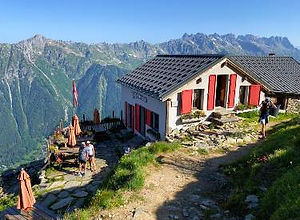
You will start the trail at the Montenvers mountain train station. You can first look around or visit the Grotte du Mer de Glace (Ice Cave) or any of the restaurants or snack bars around Montenvers. The start of the trail is well marked and you can find it across from the Montenvers Hotel. From there follow the trail marker for Signal. It is single track where you cannot go wrong. After climbing up and reaching Signal follow the signs for the Plan de l' Aiguille. Your end destination, which is the Plan de l'Aiguille lift station will be in sight and the path leading towards it will be easy to follow. As you get nearer to the lift station there will be a number of paths you can take. The path towards the Refuge de Plan de l'Aiguille is well marked and we suggest you visit the refuge for snack or a drink and great view into the Chamonix Valley. If you dont feel like making this detour then you could simply follow the signs that point you straight to the lift station. Once you are at the lift station we suggest you make a small detour and visit the Lac Bleu. This is a beautifully situated little lake and it not a big effort to add it to your day. After visiting the lake simply walk back to the lift station and take the lift down back to Chamonix town center.
Points of Interest
Our hiking and trail running trails around Chamonix are chosen for their natural beauty and variety. We also always try to combine as many sights, attractions and points of interests as possible in our trails. Below you will find a list of the points of interests linked to this trail.


