Chamonix to Plan Aiguille via Blatiere
Our Rating
7
Good
Watch the Full Video on

Length
14.09km

Elevation + / -
1209m / 1209m

Altitude Range
1035m / 2202m

When to go
Mid Jun - Mid Oct
Hike duration
4.0 - 6.0 Hours

Run duration
2.5 - 3.5 Hours

Technical level
Easy

Natural beauty
Very Nice

Families
9+ Years old

Dogs
Dogs Allowed

Provision Sources
1 Refuge, 1 Snack Bar

Trail type
Loop
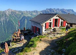
This trail starts near the center of Chamonix and takes you up to the Grand Balcon Nord via the Alpage de Blatiere. The alpage is a really nice mountain meadow with a sheep farm where in summer they serve drinks and snacks. It really is a very cute and beautiful place with some nice views across the Chamonix Valley. From there the trail continues on and meets the Grand Balcon Nord which runs between Montenvers and the Refuge du Plan de l'Aiguille. This section of the grand balcon is really beautiful with great views to be had in all directions. The Refuge Plan Aiguille makes for a perfect place for a snack or a meal before starting the big climb down back to Chamonix.
It is is a bit of a shame that both the climb up to the Alpage de Blatiere and the climb down from the Refuge du Plan de l'Aiguille are a bit monotonous consistiing mostly of pine forest trails. The sections between the Alpage and the first few hundred meters downhill from the refuge are really lovely. Your alternative is to just do the Grand Balcon Nord using the Montenvers Train and the Plan Aiguille Gondola and that trail is objectively more beautiful with more to offer. Still the Alpage de Blatiere is really quite a special place and maybe worth the climb.
Video of this Trail
We have made a video presentation for this trail. The video will provide full 3D fly over of the route and then give a great overview of the experience you can expect when you take on this trail. It is a great way to quickly understand if this is the perfect trail for you. Please visit our channel on YouTube and like the video and subscribe to our channel. Putting together these videos is a lot of work!
Photos of this Trail
Below are all the photos we have in our Chamonix Photos collection for this point of interest. All our photos are tagged with the GPS coordinates and linked to the trails that you can take to find the location where the photo was taken. So if you want to see the full details for a specific photo then just click on it.


Trail Directions & Safety Considerations

Risk Considerations & Difficulty Assessment
This route reaches an altitude of 2200 along the Grand Balcon Nord. The best time to go would be between mid June and mid October when you can assume that there will be no snow cover along the trail. But make sure to check this ahead of time as it can differ greatly each season. The trails are steep but not very technical. It is a simple trail to follow with plenty of trail markers along the way.

Children
9+ Years old

Dogs
Dogs are not allowed on the Plan de l'Aiguille and Aiguille du Midi cable cars so you will have to walk them up and down. Make sure to keep your dog on the lead near the Alpage de Blatiere and follow the instructions given on a big sign post on your way up to the Alpage


Trail Directions
The trail starts at the Parking de Biollay in front of the cemetery of Chamonix and near the Montenvers train station. The trail you need to take can be found at the far eastern end of the parking lot where you will enter the Chemin de la Cascade. Take this road up as its bends in a southern direction and becomes a trail. Follow the trail sign for the Alpage the Blatiere. There will also be a sign here that says whether or not the Alpage is open. Follow the trail up for a long way as its zigzags steeply up the mountain. You will reach a junction where you will turn left and follow the trail sign for Blatiere. You will then reach an opening and eventually the Alpage. From there follow the trail up in a south-eastern direction until you reach the next farmhouse at the Alpage Blatiere Dessus.The trail continues on until it intersects with the Grand Balcon Nord where you will turn right in a south-western direction and follow that trail until you reach the Refuge du Plan de l'Aigulle. There are trail markers pointing to the refuge along the way. From the refuge take the trail going down in a south-western direction. It is a long way down with many switchbacks. The first junction that you will eventually reach will offer you to turn left and down to the Cascade du Dard. If you want to add this to your outing then you could take this path and take the latter part of this trail to get back to Chamonix. If you want to go straight back to Chamonix, then simply stay on the trail and follow the signs for the Grepon Parking. Once you are at Grepon parking you can cross below the main road in the direction of the Aiguille du Midi cable car station. Walk past the big square where the cable car station is and turn right onto Rue du Lyret. At the round about take the first right onto Rue Helbronner. Continue on until you see a small path on your left and a sign for the Montenvers Train Station. Pass the train station and turn right at the train track crossing to be back at your starting point at the Parking de Biollay.
Points of Interest along this Trail
Our hiking and trail running trails around Chamonix are chosen for their natural beauty and variety. We also always try to combine as many sights, attractions and points of interests as possible in our trails. Below you will find a list of the points of interests linked to this trail.